Onsite Intelligence Inc.

Thirds

Software for land services firms that reads an Alberta survey plan and produces the third-party line list for it — the schedule of every external party whose consent, approval or notification the project requires.

You upload a pipeline or wellsite plan; Thirds returns a draft list of the consents and notifications the project requires — and before you accept a line, you can open it to see the feature it was read from, the distance measured, and the rule that made it a requirement.

Thirds is built with an industry partner — a land services firm running it against its own plans.
The Thirds sign-in screen: the product wordmark over a dark plan-grid background, beside a sign-in panel.

How it works

A plan goes in and a reviewed list comes out. Six steps, in the order a plan travels them.

  1. Redaction, and checking it worked — before anything is sent
  2. Upload, and the regions on the sheet
  3. Reading the legend
  4. Finding features, and identifying them
  5. Review and approval
  6. The third-party line list

Step one

Redaction, and checking it worked

A survey plan names the proponent in its title block, and commonly again in a revision block or the general notes. Before a plan is uploaded it is opened on your own workstation, in the browser, and an admin marks those regions. Every text object inside a marked region is deleted from the document, along with its metadata, its embedded XMP packet, and the original filename, which is replaced by a system-generated identifier.

Marking the regions is a manual step, deliberately. For the software to find them for you it would have to read the plan first — the unredacted plan, client name and all, leaving your office. That is the one thing redaction exists to prevent, so this step stays on your side of it.

Redaction here means deletion, not concealment. A rectangle over text leaves the text in the file, recoverable by anyone who copies it — a false assurance rather than a protection. The result is verified, not assumed: the document is re-parsed and text extraction run against the marked regions to confirm the text is gone. It also searches the rest of the sheet for what you removed and highlights every further occurrence, so a name repeated in a revision block or the general notes cannot survive by sitting somewhere you did not look.
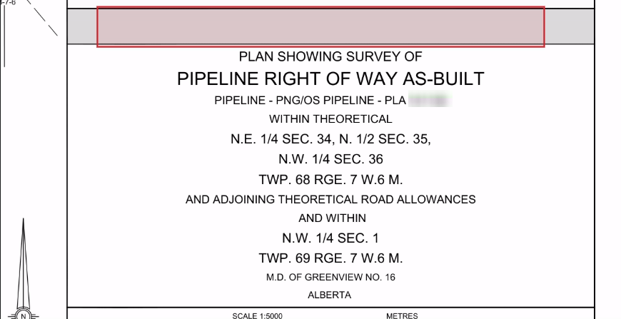
A survey plan's title block after redaction: the band that carried the client's name is empty and outlined in red, while the plan's own description below it is untouched.
The same title block once the marked band is deleted — the name is not covered, it is gone.

Step two

Upload, and the regions on the sheet

A plan arrives as a PDF. Thirds establishes whether the project is a pipeline or a wellsite, because the two are measured differently and carry different rules. Where the plan does not make that clear, it asks rather than assuming.

The drawing, the legend and the notes around it are each read differently, so an admin marks where they are on the sheet.

That marking is manual in the first version. The eventual goal is for Thirds to automatically propose the regions and the admin to confirm them.

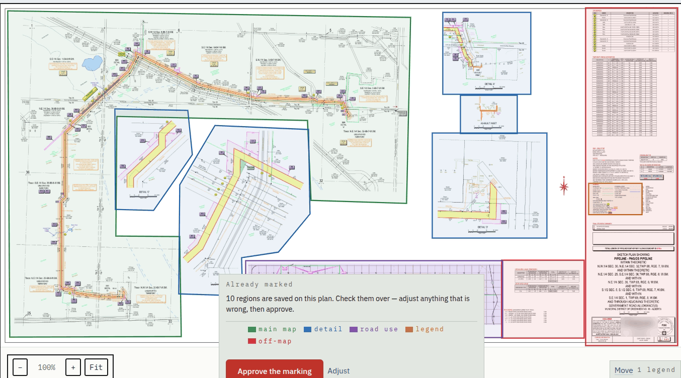
Marking the legend and the map regions on the sheet.
A survey plan with its working regions outlined and colour-coded — main map, detail, road use, legend and off-map — and the marking ready to be approved.
The marked plan, colour-coded by region and ready to approve.

Step three

Reading the legend

The legend is the plan's own key: it states what each symbol and line style means on that particular drawing. There is no industry standard and every firm draws differently, so Thirds reads the legend rather than relying on assumptions about how plans are usually drawn.

That is what lets it work on a plan from a firm it has never encountered — the plan explains its own conventions and the system reads the explanation. The extracted entries go in front of an admin to confirm before anything is built on them.
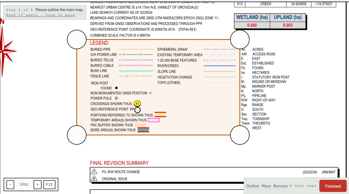
A survey plan's legend — buried pipe, overhead power line, fence line, bore areas and the rest — each with the line style or symbol that stands for it on the drawing, marked as a working region on the sheet.
A plan's legend: every symbol and line style the drawing uses, defined by the firm that drew it.

Step four

Finding features, and identifying them

With the legend confirmed, Thirds enumerates the features on the sheet and works out what each one is, matching each against the drafting conventions confirmed for the firm that drew the plan.

Deterministic code resolves what it can and narrows the rest. Where two readings both stay plausible, that residual question goes to a model; where the answers disagree, the item is escalated rather than settled by preference.

Step five

Review and approval

Thirds checks its own work before a draft reaches anyone: a failed check is reattempted rather than passed forward, and where the reattempt fails it is raised as a question.

Any line can be opened to see where it came from, what identified it, the distance measured, and the rule that produced the requirement. Any line can be corrected and any missing line added. Until an admin approves it the draft is a proposal; nothing issues on the system's own authority.
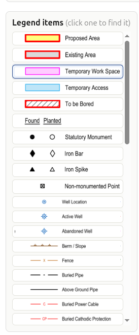
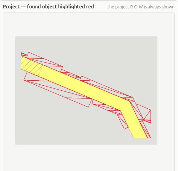
A panel listing the legend items found on the plan — proposed area, existing area, temporary work space, statutory monument, iron bar, fence, buried pipe, buried power cable and more — each with the symbol that stands for it. The plan with one extracted feature highlighted in red against the project right-of-way shown in yellow.
Objects are pulled out of the survey by deterministic code working from the legend and the drafting conventions, then checked by the AI verification system.

Step six

The third-party line list

The approved list is what the work is for: each party, the parcels involved, what the interaction is, and whether it requires a consent or only a notification. It reads as the schedule your team works from, not as a report about how it was produced — the reasoning behind a line is there to be opened and checked during review, before you accept it, rather than printed beside it on the finished list.

It is delivered in the format your firm chooses: Excel, PDF, Word, CSV, or a view with the fields ordered to match the sequence your team keys them into whatever system you work in. Ordering is a stored preference and can differ per client; it changes the sequence and never the contents.
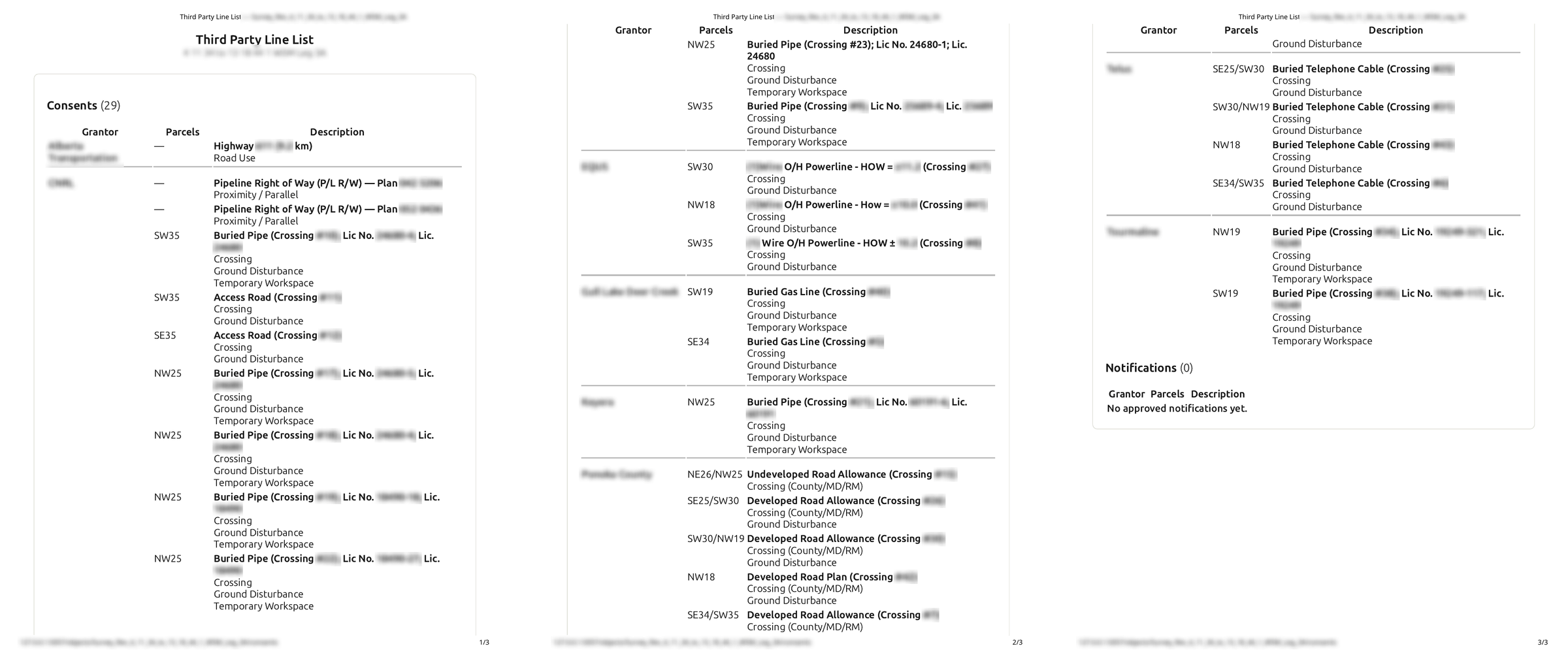
All three pages of a delivered third-party line list side by side: a Consents section listing each grantor, the parcels involved and a description of the interaction — road use, pipeline rights of way, buried pipe, gas line, powerline and telephone cable crossings, road allowances — ending with an empty Notifications section. Party names are blurred.
A delivered list, all three pages — click to read it. Party names are blurred here; on yours they are not.

Escalations

Survey plans are hard to extract data from for two reasons. There is no industry-wide standard, so the variation between firms is effectively unbounded. And plans are drawn by people, so it varies within a firm that does have a standard — along with ordinary human error.

A system that works on real plans has to adapt to that variability reliably rather than assume it away. Thirds does it by escalating: where it is not confident in the answer it has, it puts the question to an admin instead of committing. Every answer is learned from, so the escalations grow fewer over time.

n =
n — the number of ways one feature can be drawn. Nothing sets an upper bound on it, so the system cannot be built around a fixed set.

Where plans are processed, held and protected

Where it is processed, and where it is held

Project data is processed and stored within Canada, and is not transferred outside Canada in the course of the work. It is not transmitted to any external or public artificial-intelligence service: the models Thirds uses are operated privately on infrastructure under our control, and project material is not submitted to any third-party platform. We commit to Canadian residency rather than to a named hosting provider, so the guarantee survives a change of supplier.

How it is protected

Data is encrypted in transit and encrypted at rest, including backups. Encryption keys are held in managed secret storage rather than in application configuration or on the filesystem beside the data they protect. Processing infrastructure runs behind a firewall on a default-deny basis; the environment that serves the models is not exposed publicly and is reachable only over a private channel. Uploaded documents are validated before they are processed, and a file that cannot be processed safely is rejected rather than partially handled.

Backups

Backups cover the durable material above, together with any evaluation material you have supplied. No survey plan, no working data derived from one, and no draft or approved list belonging to an analysis is written to backup. Backups are taken daily, are encrypted, and are retained for seven days; restoration is tested rather than assumed. Recovery for an analysis is therefore re-processing rather than restoration — a restore cannot expose the work of an analysis, because that work is not present in what would be restored.

Who can reach a plan, and what is recorded

Access is restricted to named users your firm authorises. There is no public access and no self-registration facility. Authentication is handled by an established identity provider rather than implemented by us; multi-factor authentication is supported and may be enforced. Authorization is verified on the server for every request, including the retrieval of documents — the browser displays what it is given and is never the point at which access is decided, so a person cannot reach data by manipulating what is in front of them. Each firm's data is segregated, and authorization checks are scoped to the firm a user belongs to. Removing a user takes effect immediately, ending a session already open rather than waiting for it to expire.

Whose accounts these are

Accounts exist because someone at your firm created them. The first version supports more than one superadmin, each able to assign the admin role, together with two system administrator placements able to assign the superadmin role itself — so one person leaving or losing access does not leave nobody able to add or remove users.

What is recorded

Authentication events, uploads, approvals, corrections, deletions and administrative changes are written to an append-only log. Entries reference documents by internal identifier rather than by client or project name, so the record of what happened does not itself become a store of confidential detail.

What is kept, and for how long

Retention is organized around the analysis rather than around the project. An analysis is the processing of a single survey plan, from upload to the approved line list.

Everything belonging to an analysis — the uploaded plan, the rendered sheets, the geometry and text extracted from them, and the draft and approved lists — is deleted when the analysis ends, and none of it is written to backup. A revised survey is a new analysis and a new upload; no plan is held against the possibility that a revision may follow. You may trigger deletion of an analysis at any time. The completed list is delivered to you and kept in your own records; no copy is retained beyond the analysis. Thirds is not a document repository.

What persists between analyses is accounts and settings, the drafting conventions your admins have confirmed for the survey firms whose plans you work with — confirmed legend entries are part of them — the audit log, the anonymized learning examples, and the stored decisions an admin makes. It contains no survey plan and no client identity. Retention periods for that durable material, and the deletion process, are set in the agreement rather than assumed here.

Decisions an admin makes within an analysis — the marked regions, the approved legend, escalation answers, and corrections — are stored keyed to the content of the plan rather than to the analysis, and carry no client identity.

How an analysis is labelled

Because the client's name is not present, an analysis is identified by a reference your firm chooses. You supply your own file reference when the plan is uploaded, and that reference is the label used on every surface: the processing queue, escalations, notifications, the review screen and the delivered list. The mapping from that reference back to a client is held by your firm; it is not supplied to us and is not stored by us. Where a label appears to contain a company name the system warns — it does not refuse, because the choice of reference belongs to you.

Before launch

Thirds is being built with a land services firm running it on its own plans. Before general availability we want a few more firms to go through the initial training phase with us — real work through the system while it is still learning, and an honest account of where it gets things wrong.

At launch Thirds is licensed once and then billed monthly. The monthly fee covers hosting, inference, monitoring, the SLA, continued correction and improvement of the system, and a set number of plan uploads. Plans beyond that number are charged per plan, at a rate that steps down with volume.

Firms that take part in the training phase pay a reduced licence fee, and half of every monthly invoice for the first six months — the whole invoice, additional plans included, with no cap on the discount.


Onsite Intelligence Inc.

Confidential — please read before continuing

What follows describes Thirds, software in development by Onsite Intelligence Inc., and includes screenshots of working documents. It is provided to you for the sole purpose of evaluating whether your firm wishes to take part in the training phase or become a customer.

Confidentiality. Everything on this page — the design of the system, the commercial terms, and the documents shown — is confidential information of Onsite Intelligence Inc. By continuing you agree not to disclose it to anyone outside your firm, not to copy or publish any part of it, and not to use it for any purpose other than that evaluation. Please do not forward the link.

Third-party material. The survey plans and line lists shown are redacted examples. Party names, licence and plan numbers, and document identifiers have been removed. Nothing here is a statement about any named company or project.

In development. Thirds is being built. This page describes how the system works and what it is intended to do; it is not an offer, a specification, or a warranty, and what ships may differ. Thirds is a drafting aid — a qualified person at your firm reviews and approves every list, and professional judgement, regulatory interpretation and final responsibility for the work remain with your firm. We do not provide legal, regulatory or compliance advice.